Bay of Bengal Low-Pressure System: How It Drives Monsoon Rainfall and Himalayan Weather
From atmospheric pressure and Coriolis force to orographic rainfall, flash floods and landslides — understanding the science behind an active Indian monsoon
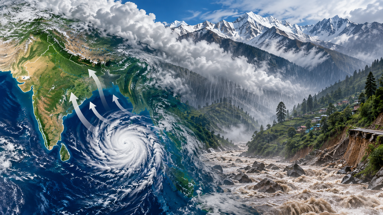
During the active phase of the Indian monsoon in September 2026, a low-pressure system over the Bay of Bengal near the Odisha–north Andhra Pradesh coast once again highlighted the crucial role played by the Bay of Bengal in India’s monsoon weather.
At first glance, a low-pressure system developing hundreds of kilometres away from the Himalayas may appear to have little connection with weather in northern India. In reality, India’s monsoon is an interconnected atmospheric system. Low-pressure systems over the Bay of Bengal can transport enormous amounts of moisture inland, influence rainfall over several states and, under favourable atmospheric conditions, contribute to intense rainfall episodes farther north.
For Himalayan states such as Himachal Pradesh, this becomes particularly important because heavy or prolonged rainfall can translate into landslides, flash floods, road blockages and cascading infrastructure failures.
So how does the entire process work?
🌧️ What Is a Low-Pressure Area?
Atmospheric air has weight and therefore exerts pressure on the Earth’s surface. This is known as atmospheric pressure.
When the atmospheric pressure over one region becomes relatively lower than that of its surroundings, it is called a low-pressure area.
Air tends to move from relatively higher pressure toward lower pressure. Consequently, near the surface, air from surrounding areas begins moving toward the low-pressure region.
This inward movement of air is known as convergence.
The basic process is:
Low Pressure → Surface Convergence → Rising Air
When converging air is forced upward, an important chain of atmospheric processes begins.
☁️ Why Does Rising Air Produce Clouds and Rain?
As an air parcel rises through the atmosphere, the surrounding atmospheric pressure decreases.
The rising air therefore expands.
Expansion causes the air parcel to cool — a process known as adiabatic cooling.
If the rising air contains sufficient moisture, continued cooling eventually causes water vapour to condense into tiny droplets.
These droplets contribute to cloud formation and, under suitable conditions, precipitation.
The complete sequence is:
Low Pressure → Convergence → Rising Moist Air → Expansion → Cooling → Condensation → Clouds → Rainfall
This is one of the most fundamental processes behind rainfall-producing weather systems.
🌊 Why Is the Bay of Bengal So Important for the Indian Monsoon?
The Bay of Bengal, situated to the east of mainland India, is one of the major moisture sources for the Indian summer monsoon.
Warm ocean water supports evaporation, supplying large quantities of water vapour to the atmosphere.
During the monsoon season, atmospheric disturbances frequently organise over the Bay of Bengal. These systems can transport moisture from the ocean deep into the Indian subcontinent.
Depending on their track and intensity, they may influence rainfall over regions such as:
Odisha → Chhattisgarh → Madhya Pradesh → adjoining central and northern parts of India
The exact route and rainfall distribution vary from one system to another.
This is why a weather system originating over the Bay of Bengal can influence areas located far away from India’s eastern coastline.
🌀 Is Every Low-Pressure Area a Cyclone?
No.
This is one of the most important misconceptions associated with monsoon weather.
A low-pressure area, depression and cyclonic storm are not synonymous terms.
A low-pressure area represents a relatively weak pressure disturbance. If atmospheric and oceanic conditions favour further organisation and intensification, it may develop into stronger categories.
A simplified conceptual sequence is:
Low-Pressure Area → Depression → Stronger Cyclonic System
However, every low-pressure area does not intensify into a cyclone.
Therefore, whenever a low-pressure area develops over the Bay of Bengal, it should not automatically be described as a cyclonic storm.
🌍 Coriolis Effect: Why Moving Air Does Not Travel in a Perfectly Straight Line
The Earth is continuously rotating.
Because we observe atmospheric motion from this rotating Earth, moving air and water appear to undergo a deflection. This phenomenon is known as the Coriolis effect.
Its direction differs between the two hemispheres:
Northern Hemisphere → Deflection toward the right
Southern Hemisphere → Deflection toward the left
India lies in the Northern Hemisphere, making the rightward deflection particularly relevant to Indian atmospheric circulation.
The Coriolis effect is very weak at the Equator and generally becomes stronger toward the poles.
This explains another important geographical phenomenon: tropical cyclones rarely originate exactly at the Equator because the Coriolis effect there is too weak to provide sufficient rotational organisation.
Remember:
North → Right
South → Left
Equator → Coriolis effect nearly zero
🏔️ What Happens When Moist Monsoon Air Reaches the Himalayas?
This is where the Bay of Bengal weather system becomes particularly relevant to Himalayan geography.
Moisture-bearing air moving across northern India eventually encounters one of the world’s greatest mountain barriers — the Himalayas.
The mountains force the incoming moist air upward.
This process is known as orographic uplift.
As the air rises:
Air rises → expands → cools → condensation occurs → precipitation develops
Rainfall generated or enhanced because air is forced to rise over mountainous terrain is known as orographic rainfall.
In simple terms:
Moist Air + Mountain Barrier = Forced Uplift → Cooling → Rainfall
🌧️ Windward, Leeward and Rain Shadow
A mountain barrier has two important sides in relation to incoming airflow.
Windward Side
The side facing the incoming moisture-bearing wind is called the windward side.
Air is forced upward along this side, which generally favours greater precipitation.
Leeward Side
After crossing the mountain barrier, air descends on the opposite side.
This is the leeward side, which may experience relatively drier conditions.
Where this drying effect becomes significant, a rain-shadow region can develop.
Thus, mountains do not merely receive rainfall — they can dramatically redistribute it.
🏔️ How Can a Bay of Bengal Weather System Affect Himachal Pradesh?
A low-pressure system over the Bay of Bengal should not be interpreted as a “cyclone reaching Himachal Pradesh.”
The connection is more complex.
Monsoon circulation can transport moisture from the Bay of Bengal toward inland and north-western India. Rainfall over Himachal Pradesh then depends on the interaction of several atmospheric and geographical factors, including:
Monsoon circulation + moisture availability + local convergence + western disturbances + Himalayan topography
When these factors interact favourably, rainfall over parts of the western Himalayas can intensify.
And in a steep mountain environment, intense rainfall can quickly become a disaster-management concern.
⚠️ From Rainfall to Landslides: The Hidden Process Inside a Mountain Slope
Heavy rainfall does not merely increase river water.
Some rainwater enters soil and weathered rock through a process known as infiltration.
As more water enters the slope, pore spaces between soil and rock particles become increasingly water-filled.
This can increase pore-water pressure.
Higher pore-water pressure can reduce effective stress, weakening the frictional resistance that helps keep slope material stable.
The simplified chain is:
Heavy Rain → Infiltration → Saturation → Pore-Water Pressure ↑ → Effective Stress ↓ → Slope Stability ↓ → Landslide Probability ↑
This is why prolonged or intense monsoon rainfall can trigger landslides on already vulnerable Himalayan slopes.
However, rainfall is not the only factor.
Slope angle, fractured geology, river erosion, road cutting, drainage conditions and human modification can all influence slope stability.
🌊 Why Are Flash Floods Particularly Dangerous in the Himalayas?
A flash flood is a rapid-onset flood characterised by a very short response time.
Himalayan catchments are particularly susceptible because many have:
- steep gradients,
- narrow valleys,
- short drainage paths,
- rapid surface runoff.
When intense rainfall occurs, water can reach streams and rivers very quickly.
Consequently:
Intense Rainfall → Rapid Runoff → Sudden Rise in Stream Discharge → Flash Flood
This gives communities considerably less response time than many gradually developing riverine floods.
⛈️ Heavy Rain Is Not the Same as a Cloudburst
This distinction is extremely important.
Every episode of heavy rainfall should not be described as a cloudburst.
A cloudburst is an exceptionally intense and highly localised rainfall event. In Indian meteorological usage, it is commonly associated with rainfall of around 100 mm or more within one hour over a small area.
Therefore:
Heavy Rain ≠ Automatically a Cloudburst
Similarly:
Cloudburst ≠ Flash Flood
A cloudburst is a meteorological event involving extremely intense rainfall, whereas a flash flood is a hydrological event involving rapidly rising and moving water.
A cloudburst can trigger a flash flood, but every flash flood need not necessarily originate from a cloudburst.
🔗 The Cascading Disaster Effect
The consequences of intense Himalayan rainfall often extend far beyond the initial landslide or flood.
Consider this sequence:
Heavy Rainfall
↓
Landslide
↓
Highway Blocked
↓
Electricity/Telecom Infrastructure Damaged
↓
Village Becomes Isolated
↓
Ambulance and Rescue Access Delayed
This is an example of a cascading disaster, in which one initial hazard triggers a series of secondary failures across interconnected systems.
For mountain states such as Himachal Pradesh, disaster resilience therefore requires more than forecasting rainfall. It also requires resilient roads, drainage, power systems, communications and emergency-response networks.
🗺️ Important Map Locations to Remember
For geography and competitive examinations, a few basic map relationships are essential.
Bay of Bengal — East of mainland India
Arabian Sea — West of India
Odisha — Eastern coast facing the Bay of Bengal
Andhra Pradesh — Eastern/south-eastern coast facing the Bay of Bengal
Lakshadweep — Arabian Sea
Andaman and Nicobar Islands — Bay of Bengal–Andaman Sea region
Himalayas — Major northern mountain barrier influencing monsoon circulation
A common examination trap is to interchange the locations of Lakshadweep and the Andaman & Nicobar Islands.
🎯 Important Concepts for HPAS/HPPSC Aspirants
The current weather development should be used to revise a much larger static-geography package.
Low Pressure
A region where atmospheric pressure is relatively lower than its surroundings.
Convergence
The horizontal movement of air toward a common region, often encouraging upward motion.
Adiabatic Cooling
Cooling of a rising air parcel as it expands under decreasing atmospheric pressure.
Coriolis Effect
Apparent deflection of moving air and water due to Earth’s rotation — rightward in the Northern Hemisphere and leftward in the Southern Hemisphere.
Orographic Rainfall
Precipitation produced when moist air is forced to rise over elevated terrain, cools and condenses.
Flash Flood
A rapidly developing flood characterised by a short response time.
Cloudburst
An exceptionally intense and highly localised rainfall event.
⚠️ Five Examination Traps You Should Never Miss
1. Every low-pressure area is a cyclone — FALSE
A low-pressure area may or may not intensify into a cyclonic system.
2. Coriolis effect is strongest at the Equator — FALSE
It is essentially zero at the Equator.
3. In the Northern Hemisphere, Coriolis deflects moving air to the right — TRUE
4. Every heavy-rain episode is a cloudburst — FALSE
Cloudburst has a much more specific meaning involving exceptionally intense localised rainfall.
5. A Bay of Bengal low-pressure system means a cyclone has reached Himachal Pradesh — FALSE
The connection occurs through larger monsoon circulation, moisture transport and interaction with other atmospheric and topographic factors.
📝 Probable Prelims Question
Consider the following statements:
- A surface low-pressure system can promote convergence of air.
- Rising moist air may undergo expansion and cooling.
- Orographic uplift can enhance rainfall over mountainous regions.
- Every low-pressure area over the Bay of Bengal eventually becomes a cyclonic storm.
Which of the statements given above are correct?
Answer: 1, 2 and 3 only.
🌧️ The Bigger Picture
A low-pressure system over the Bay of Bengal is much more than a small symbol on a weather map.
It demonstrates how India’s climate functions as an interconnected system.
Warm ocean waters supply moisture. Atmospheric pressure differences organise air movement. Earth’s rotation modifies winds through the Coriolis effect. Moisture-bearing circulation transports water vapour across the subcontinent. The Himalayas then reshape that airflow through orographic uplift.
Under intense conditions, the same atmospheric processes that sustain India’s monsoon can contribute to floods, landslides and infrastructure disruption in vulnerable mountain environments.
The complete geographical story can therefore be summarised in one chain:
Bay of Bengal → Moisture → Low Pressure → Convergence → Rising Air → Adiabatic Cooling → Condensation → Monsoon Rainfall → Inland Moisture Transport → Himalayan Orographic Uplift → Enhanced Rainfall → Flash-Flood & Landslide Risk
Understanding this chain is far more useful than simply memorising that a low-pressure area developed over the Bay of Bengal. It connects meteorology, climatology, physical geography, geomorphology and disaster management into a single real-world event — exactly the kind of current-static integration increasingly important for competitive examinations.