Topography of the Himalayas: Understanding the Surface Features of the Youngest Fold Mountains of the World
Introduction
The Himalayas are among the most remarkable mountain systems on Earth. Stretching for about 2500 kilometres from the Indus Gorge in the west to the Brahmaputra Gorge in the east, they form the northern boundary of the Indian subcontinent. The Himalayas are not only the highest mountains in the world but also among the youngest fold mountains, making them a dynamic and evolving landscape.
The topography of the Himalayas is characterized by lofty snow-covered peaks, deep river gorges, steep slopes, extensive glaciers, V-shaped valleys, interlocking spurs, river terraces and a variety of glacial landforms. These features provide valuable evidence of the geological history, tectonic activity and geomorphic processes that have shaped the Himalayan region over millions of years.
Understanding Himalayan topography is essential because it forms the basis for studying Indian climate, drainage systems, natural hazards, biodiversity and regional development.
What is Topography?
Topography refers to the external surface features and relief characteristics of a region. It includes the arrangement and distribution of mountains, valleys, plateaus, ridges, slopes, rivers and other landforms.
In the context of the Himalayas, topography describes:
- Mountain peaks
- Ridges and ranges
- River valleys
- Deep gorges
- Glacial landforms
- Snowfields
- River terraces
- Interlocking spurs
Thus, while the structure of the Himalayas explains how the mountains were formed, topography explains how the mountains appear on the Earth’s surface.
Himalayas: The Youngest Fold Mountains
The Himalayas were formed as a result of the collision between the Indian Plate and the Eurasian Plate during the Tertiary period. Since their formation is relatively recent in geological history, they are regarded as the youngest fold mountains of the world.
Their youthful nature is reflected in:
- Extremely high elevations
- Sharp peaks
- Deep valleys
- Active tectonic movements
- Frequent earthquakes
- Rapid erosion
The ongoing tectonic activity continues to uplift the Himalayas, making them one of the most dynamic mountain systems on Earth.
Rejuvenation of Rivers and Antecedent Drainage
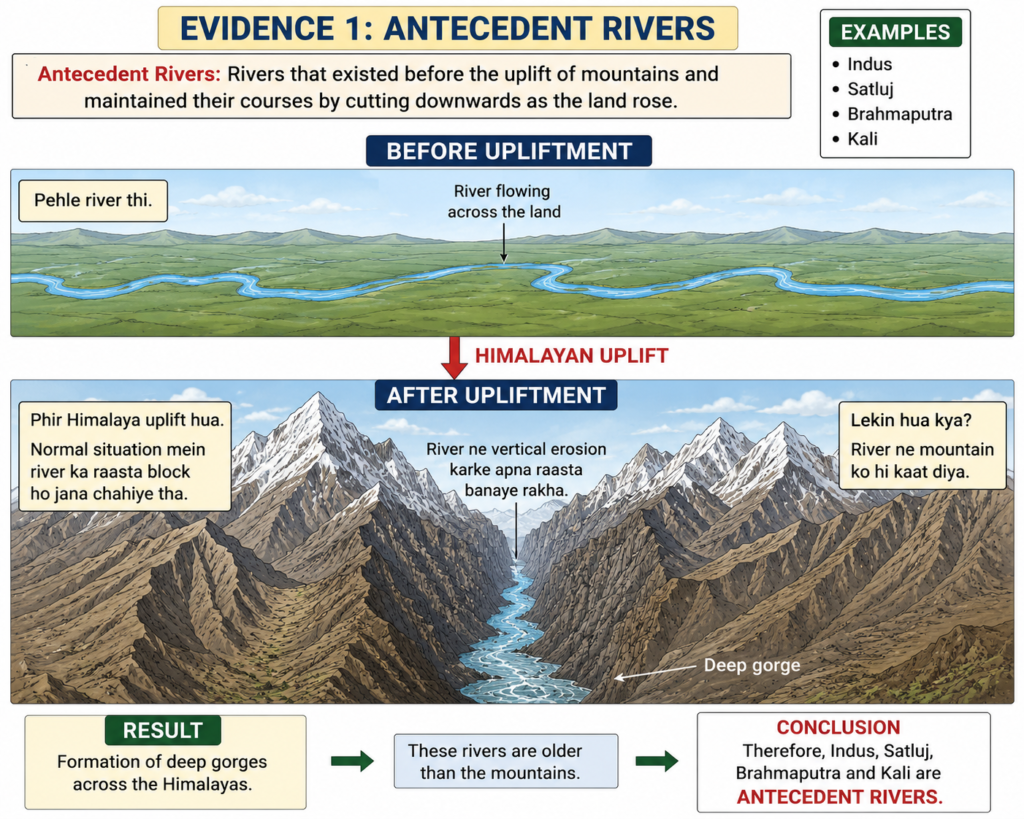
One of the most fascinating aspects of Himalayan topography is the presence of antecedent rivers.
An antecedent river is a river that existed before the upliftment of the mountains through which it flows. As the Himalayas gradually rose due to tectonic forces, some rivers maintained their original courses by continuously eroding downward at a rate sufficient to keep pace with uplift.
Important antecedent rivers include:
- Indus
- Satluj
- Brahmaputra
- Kali
These rivers cut deep gorges through the rising mountain ranges, proving that they are older than the mountains themselves.
The presence of antecedent drainage is one of the strongest pieces of evidence supporting the theory of continuous Himalayan uplift.
Deep Gorges: Signatures of Active Erosion
The antecedent rivers of the Himalayas have carved some of the deepest gorges in the world.
A gorge is a narrow and extremely deep valley with steep sides, formed due to intense river erosion.
Examples include:
- Indus Gorge
- Brahmaputra Gorge
- Satluj Gorge
These gorges demonstrate the immense erosional power of Himalayan rivers and indicate the tectonic youthfulness of the mountain system.
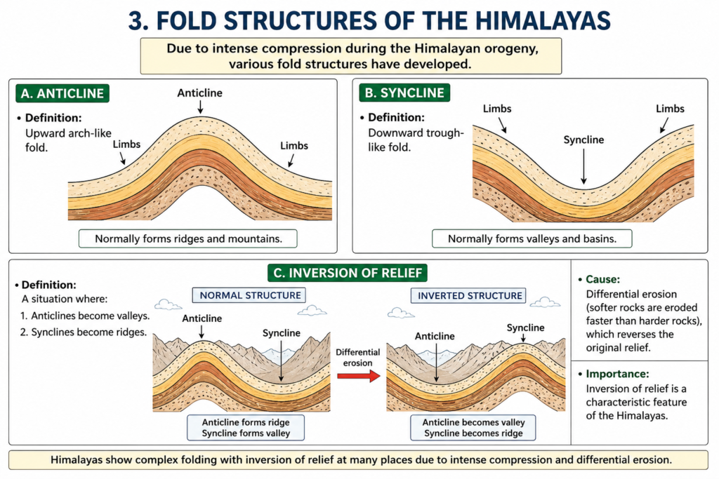
Folded Topography of the Himalayas
Since the Himalayas are fold mountains, they exhibit a wide variety of fold structures.
Anticlines
An anticline is an upward arch-like fold formed due to compression.
Normally, anticlines form ridges and mountain crests.
Synclines
A syncline is a downward trough-like fold.
Normally, synclines form valleys.
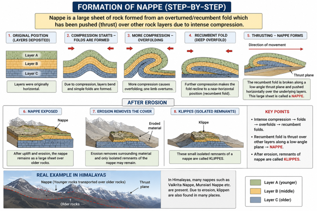
Overfolds and Recumbent Folds
As compressional forces increase, folds become increasingly distorted.
In overfolds, one limb of the fold overturns.
In recumbent folds, the fold becomes nearly horizontal due to extreme compression.
These structures are common in the Himalayas and indicate intense tectonic activity.
Nappes: Evidence of Extreme Compression
One of the most significant structural features associated with Himalayan topography is the presence of nappes.
A nappe is a large sheet of rock that has been folded, overturned and thrust over another rock mass due to intense compression.
The formation of nappes can be understood through the following sequence:
Compression → Folding → Overfolding → Recumbent Folding → Thrusting → Nappe Formation
Nappes provide clear evidence of the enormous compressional forces generated during the collision of the Indian and Eurasian plates.
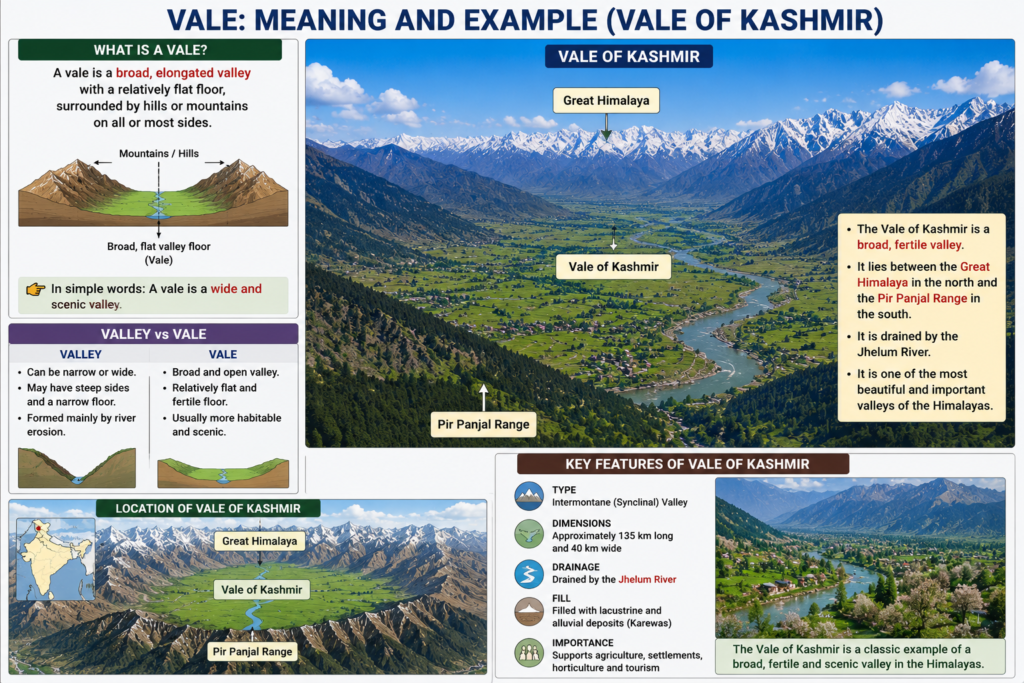
Kashmir Valley: The Largest Intermontane Valley
Unlike many mountain systems of the world, the Himalayas do not contain extensive intermontane plateaus or large basins.
The most notable exception is the Kashmir Valley.
Key Features
- Approximate dimensions: 135 km × 40 km
- Considered a synclinal valley
- Filled with sediments deposited by the Jhelum River
The valley represents the largest level tract of land within the Himalayan region and supports a dense human population.
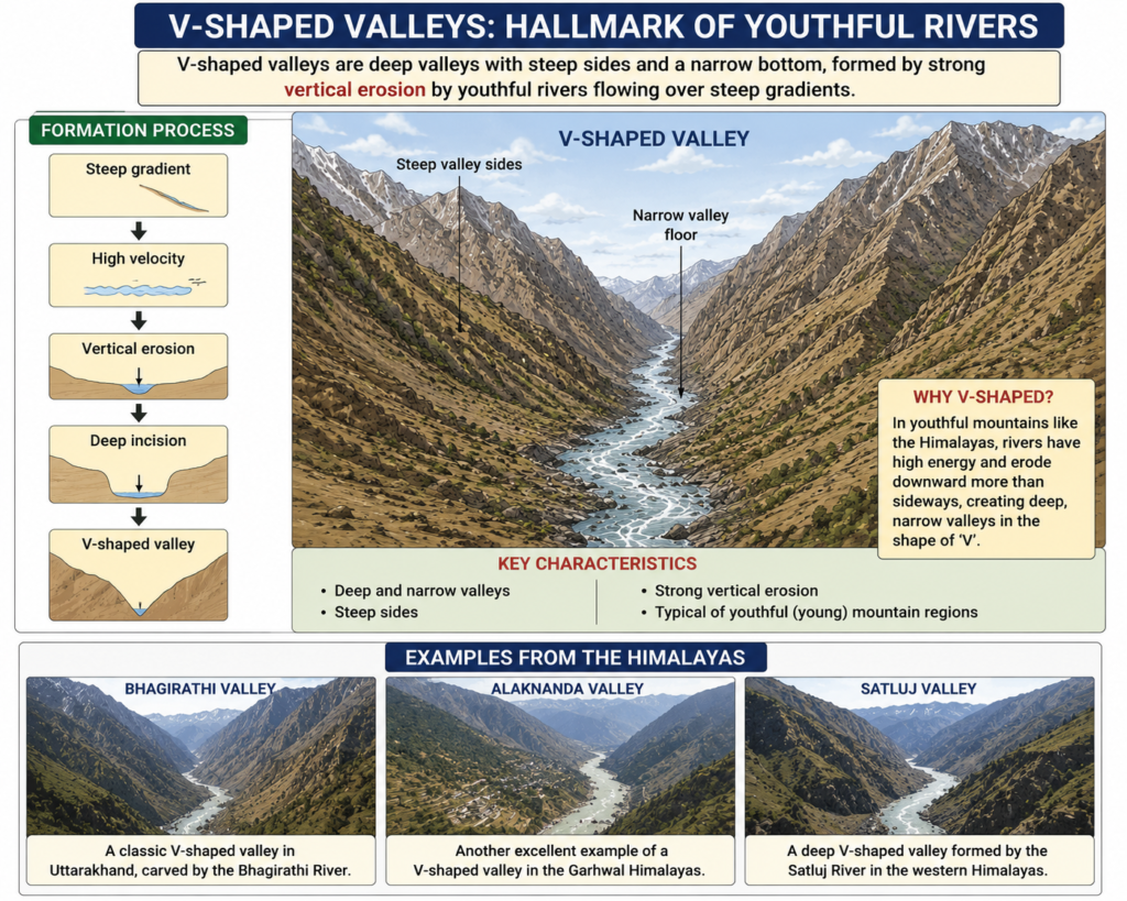
V-Shaped Valleys: Hallmark of Youthful Rivers
One of the most characteristic features of Himalayan topography is the presence of deep V-shaped valleys.
These valleys are formed by strong vertical erosion carried out by youthful rivers flowing over steep gradients.
Formation Process
Steep gradient
↓
High velocity
↓
Vertical erosion
↓
Deep incision
↓
V-shaped valley
The Bhagirathi, Alaknanda and Satluj valleys are excellent examples of such landforms.
Interlocking Spurs
As rivers cut through mountainous terrain, they often follow paths of least resistance rather than flowing in straight lines.
This produces alternating ridges projecting into river valleys.
These projections are known as interlocking spurs.
Interlocking spurs are a typical feature of youthful mountain landscapes and indicate active river erosion.
Glacial Topography of the Greater Himalayas
The Greater Himalayas exhibit extensive glacial landscapes due to permanent snow cover and low temperatures.
Several important glacial landforms are found in this region.
Moraines
Moraines are accumulations of debris deposited by glaciers.
They consist of:
- Boulders
- Gravel
- Sand
- Rock fragments
Corrie (Cirque)
A corrie is a bowl-shaped depression where a glacier originates.
These are often described as natural amphitheatres carved by glacial erosion.
Arête
An arête is a sharp knife-edged ridge formed between two adjacent cirques or glacial valleys.
Pyramidal Peaks
When several cirques erode a mountain from different sides, a sharp pointed summit known as a pyramidal peak is formed.
These landforms collectively indicate the importance of glacial processes in shaping Himalayan topography.
Periglacial Features and Solifluction
Not all landforms in the Himalayas are directly produced by glaciers.
Areas adjacent to glaciers experience freeze-thaw action and develop periglacial features.
One of the most important periglacial processes is solifluction.
Solifluction refers to the slow downslope movement of water-saturated soil under cold climatic conditions.
It commonly occurs in areas near the snowline where seasonal thawing takes place.
Snowfields and the Snowline
The Himalayas contain extensive permanent snowfields covering approximately 40,000 square kilometres from Kashmir to Assam.
These snowfields play a crucial role in maintaining the perennial nature of Himalayan rivers.
Importance of Snowfields
- Feed glaciers
- Sustain river flow throughout the year
- Support water security in northern India
The permanent snowline in the Himalayas lies at approximately 5700 metres above sea level.
Above this altitude, snow persists throughout the year.
Himalayas: Not a Single Mountain Chain
A common misconception is that the Himalayas form a single continuous mountain range.
In reality, the Himalayas consist of several parallel and converging ranges separated by valleys and structural depressions.
Important valleys include:
- Kashmir Valley
- Kangra Valley
- Kullu Valley
- Kathmandu Valley
- Bhagirathi Valley
- Mandakini Valley
These valleys act as centres of human settlement, agriculture and tourism.
Inversion of Relief
One of the most interesting geomorphic phenomena observed in the Himalayas is inversion of relief.
Under normal conditions:
- Anticlines form ridges
- Synclines form valleys
However, due to differential erosion, the reverse situation may develop:
- Anticlines become valleys
- Synclines become ridges
This phenomenon is known as inversion of relief and is a characteristic feature of Himalayan topography.
River Terraces: Evidence of Continued Uplift
River terraces are step-like benches found along river valleys.
They are formed when rivers repeatedly cut downward in response to periodic tectonic uplift.
Formation
Uplift
↓
River Incision
↓
Terrace Formation
The presence of river terraces along rivers such as the Bhagirathi, Alaknanda and Pindar indicates that the Himalayas have undergone intermittent uplift over geological time.
Valley Morphology in Different Himalayan Regions
The valleys of the Himalayas display significant regional variation.
Kashmir Himalaya
Characterized by:
- U-shaped valleys
- Deep gorges
- Open V-shaped valleys
This diversity reflects the combined action of glaciers and rivers.
Ganga Headwater Region
Dominated by V-shaped valleys due to active river erosion.
Eastern Himalayas
The valleys are generally steeper because of higher elevations and greater relief.
Significance of Himalayan Topography
The topography of the Himalayas influences almost every aspect of the Indian environment.
Climatic Importance
- Acts as a barrier to cold winds from Central Asia.
- Controls the Indian monsoon.
Hydrological Importance
- Source of major perennial rivers.
- Supports irrigation and hydropower.
Ecological Importance
- Rich biodiversity.
- Diverse vegetation zones.
Economic Importance
- Tourism
- Hydropower generation
- Horticulture
- Pastoral activities
Strategic Importance
- Forms India’s natural northern frontier.
Conclusion
The topography of the Himalayas reflects the combined effects of tectonic uplift, river erosion, glacial action and climatic processes. Features such as antecedent rivers, deep gorges, V-shaped valleys, interlocking spurs, glacial landforms, river terraces and inversion of relief collectively reveal the dynamic nature of the Himalayan mountain system.
As one of the youngest and most active fold mountain systems in the world, the Himalayas continue to evolve. Their topography not only provides insight into Earth’s geological history but also shapes the climate, rivers, ecology and economy of the Indian subcontinent.