Physiography of India: A Detailed Study of Physiographical Divisions of India
Introduction
India is one of the most physiographically diverse countries in the world. Within a relatively limited geographical area, the country exhibits some of the highest mountain ranges, vast alluvial plains, ancient plateaus, arid deserts, extensive coastlines, and island groups of different geological origins. This remarkable diversity has profoundly influenced India’s climate, drainage systems, agriculture, biodiversity, settlement patterns, economic activities, and cultural development.
The study of these physical features is known as Physiography. Understanding the physiography of India is fundamental for Geography because almost every geographical phenomenon—whether monsoon rainfall, river systems, soil formation, vegetation distribution, agriculture, or population concentration—is directly or indirectly influenced by the country’s physical structure.
What is Physiography?
The term Physiography is derived from two words:
- Physio = Nature or Physical Features
- Graphy = Description or Study
Thus, Physiography refers to the study of the natural physical features of the Earth’s surface.
In simple terms, physiography explains:
- How the land is shaped.
- Why mountains, plains, plateaus, and coasts exist.
- How these landforms influence human and natural activities.
Relief Structure of India
India’s land surface consists of diverse relief features. The approximate distribution is as follows:
| Landform | Percentage of Total Area |
|---|---|
| Mountains | 10.6% |
| Hills | 18.5% |
| Plateaus | 27.7% |
| Plains | 43.2% |
This distribution indicates that although mountains occupy a relatively smaller area, they exert a disproportionately large influence on the country’s climate, water resources, ecology, and strategic security. The plains and plateaus together account for more than 70 percent of India’s area, making them crucial regions for agriculture, settlements, and economic development.
Major Physiographic Features of India
India’s physical landscape can broadly be understood through four major physiographic divisions:
- Northern Mountains
- Great Plains
- Peninsular Uplands (Plateau Region)
- Indian Coasts and Islands
Each of these regions possesses distinct geological history, relief characteristics, and environmental significance.
The Northern Mountains: The Himalayan Realm
The northern boundary of India is dominated by the mighty Himalayan mountain system. These mountains are among the most spectacular physical features on Earth.
The Himalayas are characterized by:
- Snow-covered peaks
- Valley glaciers
- Deep river gorges
- Longitudinal valleys
- Dense forests
- Rich biodiversity
- Cultural diversity
The region is inhabited by numerous ethnic groups and communities, including the Ladakhis in the western Himalayas, Kumaunis in the central Himalayas, and various tribal communities in the eastern Himalayas.
The Himalayas are not merely mountain ranges; they are the source of many major rivers and act as a climatic barrier that protects the Indian subcontinent from cold Central Asian winds.
The Great Northern Plains
South of the Himalayas lies one of the largest and most fertile alluvial plains in the world—the Great Northern Plains.
These plains have been formed by the deposition of sediments brought by three major river systems:
- Indus
- Ganga
- Brahmaputra
Over millions of years, these rivers deposited enormous quantities of alluvium, creating vast fertile plains suitable for agriculture and dense human settlements.
The landscape of the alluvial plains is marked by several fluvial features such as:
Meanders
Meanders are winding bends formed by rivers as they flow across flat terrain.
River Bluffs
Steep banks formed along river channels due to differential erosion.
Oxbow Lakes
These are crescent-shaped lakes formed when a meander loop gets cut off from the main river channel.
Floodplains
Flat fertile areas periodically inundated during floods.
These features make the Northern Plains a classic example of a depositional landscape created by rivers.
The Indian Desert
The northwestern part of India is occupied by the Great Indian Desert, commonly known as the Thar Desert.
Major characteristics include:
- Sandy terrain
- Sparse vegetation
- Low rainfall
- Sand dunes
- Seasonal streams
Most rivers in the desert are ephemeral in nature, meaning they flow only during and immediately after rainfall events. Many of these streams disappear before reaching the sea.
Despite its harsh environment, the desert supports unique ecosystems and human adaptations.
The Peninsular Uplands: The Ancient Core of India
Towards the south, the Northern Plains gradually merge into the Peninsular Plateau.
This region represents the oldest and most stable landmass of India. Geologically, it forms the ancient shield area of the Indian subcontinent.
The Peninsular Uplands exhibit several distinctive features:
- Flat-topped plateaus
- Residual hills
- Broad valleys
- Escarpments (scarps)
- Ancient erosional surfaces
Over millions of years, weathering and erosion have reduced the ruggedness of this region, producing what geographers often describe as a mature to senile landscape.
The plateau region forms the backbone of India’s mineral resources and contributes significantly to agriculture, industry, and hydropower generation.
Coastal Plains of India
The Peninsular Plateau is surrounded by coastal plains of varying width.
These coastal regions are characterized by:
- Beaches
- Lagoons
- Deltas
- Estuaries
- Coastal wetlands
Several important lakes and lagoons occur along the coast, including:
Chilika Lake (Odisha)
- Largest brackish water lagoon in India.
- Important Ramsar wetland.
Pulicat Lake
- Second largest lagoon in India.
- Located between Andhra Pradesh and Tamil Nadu.
Kolleru Lake
- One of the largest freshwater lakes in India.
- Located in Andhra Pradesh.
The coastal plains play an important role in fisheries, ports, trade, tourism, and biodiversity conservation.
Understanding Lagoons
A lagoon is a shallow coastal water body separated from the sea by a sand bar, barrier beach, spit, or coral reef.
Unlike ordinary lakes, lagoons maintain some connection with the sea and often contain brackish water, which is a mixture of fresh and salt water.
Examples:
- Chilika Lagoon
- Pulicat Lagoon
Lagoon formation is an important coastal geomorphic process and frequently appears in competitive examinations.
Islands of India
India possesses two major island groups:
Lakshadweep Islands
Located in the Arabian Sea, these islands are primarily of coral origin. They have developed on submerged volcanic foundations through the growth of coral organisms.
Andaman and Nicobar Islands
Located in the Bay of Bengal, these islands are tectonic in origin and form part of a submerged mountain chain.
Their geological history is linked with the mountain-building processes that shaped the eastern extension of the Himalayas.
Physiographic Classification of India
According to physiographic classifications based on:
- Stratigraphic history
- Tectonic evolution
- Relief characteristics
- Erosional processes
India can be divided into several physiographic regions.
In broader terms, four major physiographic divisions are recognized:
- Northern Mountains
- Great Plains
- Peninsular Uplands
- Coasts and Islands
This classification helps geographers understand the relationship between geological structure and surface landforms.
The Northern Mountains: A Closer Look
The Himalayan mountain system extends for approximately 2500 kilometres from the western border of Pakistan to the eastern boundary near Myanmar.
Important Dimensions
- Length: Approximately 2500 km
- Width: 240–320 km
- Area: About 500,000 square kilometres
The Himalayas form a vast arcuate or bow-shaped mountain chain extending between the Indus River in the west and the Brahmaputra River in the east.
Why Are the Himalayas Arc-Shaped?
The Himalayan arc is the result of the collision between the Indian Plate and the Eurasian Plate.
As the Indian Plate moved northward and collided with Eurasia, immense compressional forces folded and uplifted the sediments of the ancient Tethys Sea.
This tectonic process produced the curved mountain belt that we now recognize as the Himalayas.
The Meaning of Himalaya
The word Himalaya originates from Sanskrit:
- Hima = Snow
- Alaya = Abode or Home
Thus, Himalaya literally means “The Abode of Snow.”
Youngest Fold Mountains of the World
The Himalayas are regarded as the youngest and highest fold mountains on Earth.
Their youthful nature is reflected in:
- Great heights
- Sharp peaks
- Deep valleys
- Active tectonic movements
- Frequent earthquakes
- Landslides
Several peaks rise above 8000 metres, making the Himalayas the highest mountain system in the world.
Three Parallel Ranges of the Himalayas
The Himalayas consist of three major parallel mountain ranges:
1. Himadri (Greater Himalaya)
- Northernmost range
- Highest peaks
- Permanent snow cover
- Source region of major glaciers
2. Himachal (Lesser Himalaya)
- Located south of Himadri
- Contains famous ranges such as Pir Panjal and Dhauladhar
- Important valleys and hill stations are situated here
3. Shiwalik (Outer Himalaya)
- Southernmost range
- Composed largely of unconsolidated sediments
- Most vulnerable to erosion
Antecedent Rivers and Himalayan Gorges
One of the most fascinating features of the Himalayas is the presence of antecedent rivers.
An antecedent river is a river that existed before the upliftment of the mountains through which it flows.
As the Himalayas rose, rivers such as:
- Indus
- Satluj
- Kali
- Kosi
- Brahmaputra
continued eroding downward at a rate sufficient to maintain their courses.
As a result, they carved deep gorges across the mountain ranges.
This phenomenon provides important evidence regarding the tectonic evolution of the Himalayas.
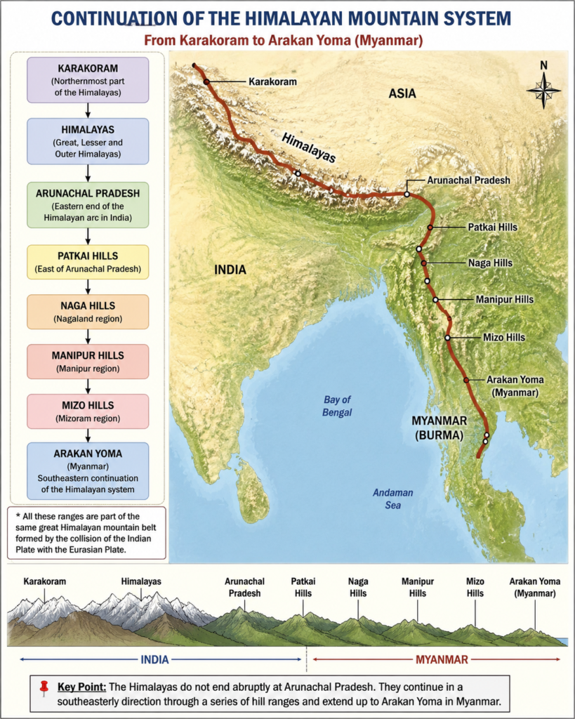
Eastern Continuation of the Himalayas
A common misconception is that the Himalayas end in Arunachal Pradesh.
In reality, the Himalayan mountain system continues southward through:
- Patkai Hills
- Naga Hills
- Manipur Hills
- Mizo Hills
and finally extends into Myanmar as the:
Arakan Yoma (Rakhine Yoma)
Arakan Yoma represents the southeastern continuation of the Himalayan folded mountain belt and forms an important link between the Himalayas and the mountain systems of Southeast Asia.
Conclusion
The physiography of India reflects a unique combination of geological evolution, tectonic processes, and erosional history. From the snow-clad Himalayas in the north to the ancient Peninsular Plateau in the south, from fertile alluvial plains to coastal lagoons and island chains, every physiographic unit contributes to the geographical identity of the country.
A sound understanding of India’s physiography is essential not only for Geography students and civil services aspirants but also for comprehending the broader relationships between landforms, climate, rivers, ecosystems, and human activities. It serves as the foundation upon which the entire structure of Indian Geography is built.