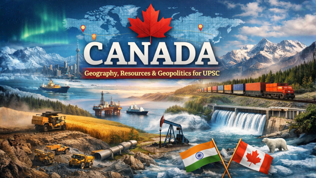
CANADA: GEOGRAPHY, RESOURCES AND GEOPOLITICS – A UPSC SYNTHESIS
Syllabus: UPSC GS-I: Physical Geography, GS-II: India–Canada relations, GS Paper-III: Economy & Environment
1. Strategic Overview – “Excess of Geography”
Canada, the second-largest country in the world (9.98 million sq km), is a classic example of how physical space shapes national power. Bounded by the Arctic, Atlantic and Pacific Oceans and sharing the world’s longest land border with the United States, Canada functions as a bridge between North America, Europe and Asia.
For UPSC, Canada illustrates:
- Interaction of plate tectonics & glaciation
- Resource-driven economy
- Arctic geopolitics
- Role of diaspora in foreign policy
Five Themes of Geography – Canadian Context
- Location: Tri-oceanic state; gateway to US market and Asia–Europe routes
- Place: From Cordilleran mountains to Arctic tundra
- Region: Formal (provinces), functional (USMCA trade corridors), perceptual (“The North”)
- Movement: From fur-trade river routes to digital globalization
- Human–Environment Interaction: Mining, dams, prairie agriculture
2. Physical Geography & Physiographic Regions
Canada’s landscape is the product of two great forces:
- Plate tectonics – creation of the Western Cordillera
- Pleistocene glaciation – scraping the Shield and depositing fertile soils southward
Major Physiographic Divisions
(a) Canadian Shield
- Precambrian crystalline core – among Earth’s oldest rocks
- Landscape of bare rock, lakes, wetlands
- Rich in nickel (Sudbury), uranium, gold, copper, diamonds
- Backbone of Canada’s hydropower (James Bay project)
(b) Interior Plains / Prairies
- Alberta–Saskatchewan–Manitoba
- “Wheat basket of Canada”
- Major reserves of oil, gas, potash
- Historically vulnerable (e.g., 1930s Dust Bowl)
(c) Western Cordillera
- Rockies, Coast Range, Interior Plateaus
- Young fold mountains, seismic activity
- Timber, minerals, hydropower
- Highest peak of Rockies – Mt. Robson
(d) Appalachian Region
- Old eroded mountains in the east
- Coal, gypsum, fishing economy
(e) St. Lawrence Lowlands
- Fertile soils pushed from Shield
- Industrial–urban heartland: Toronto–Montreal corridor
(f) Arctic Region
- Tundra, permafrost, Innuitian Mountains
- Rising importance due to melting sea ice & Arctic routes
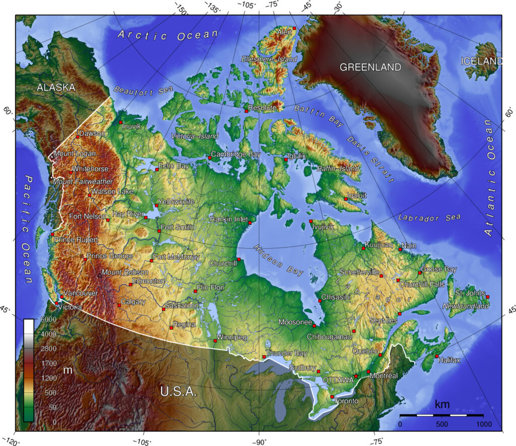
3. Drainage and Climate
Rivers & Lakes
- Mackenzie → Arctic Ocean
- St. Lawrence → Atlantic (Great Lakes outlet)
- Fraser, Columbia → Pacific
- Nelson–Saskatchewan → Hudson Bay
Climate Controls
- High latitude
- Labrador Current (cold east)
- North Pacific Current (mild west)
- Rocky Mountain rain-shadow
Biomes: Arctic tundra → Boreal taiga → Prairie grasslands → Mixed forests.
4. Economic Geography
Agriculture – Global Food Security Role
- 3rd largest wheat exporter; largest exporter of high-protein wheat
- 2024 production: 34.3 million tonnes (≈25.4 mt for export)
- Quality varies with drought in Saskatchewan–Alberta, showing climate vulnerability
Minerals & Energy
- Potash (vital for India’s fertiliser security)
- Oil sands – Athabasca (Alberta)
- Uranium – Saskatchewan
- World leader in hydroelectricity
Industry & Transport
- Auto, aerospace, pulp & paper
- St. Lawrence Seaway, Trans-Canada Highway
- Emerging North-West Passage
5. Human & Cultural Geography
- Population ≈ 40 million, highly urbanised
- Indigenous peoples – First Nations, Inuit, Métis
- Bilingual state – English & French
- Multicultural model inspired by inclusion
Indian Diaspora – Soft Power
- ≈ 1.8 million people of Indian origin
- Over 15 MPs of Indian origin
- India – top source of students & Start-up Visa participants
- Sikh Heritage Month reflects deep cultural integration
6. Political System & Global Role
- Federal parliamentary democracy, constitutional monarchy
- Member of G7, NATO, Five Eyes, Arctic Council
- Trade framework: USMCA
Canada’s foreign policy oscillates between:
- Continentalism – focus on US
- Bilateralism – outreach to emerging powers like India
7. India–Canada Relations
Pillars
- Civil nuclear & space (ISRO–CSA)
- Education & research (Shastri Institute)
- Energy and clean tech
- $12+ billion trade (CEPA talks currently paused)
Recent Challenges
- 2023 diplomatic crisis over Khalistan issue
- Visa disruptions, expulsion of diplomats
- Role of Five Eyes intelligence
India’s concern: sovereignty & territorial integrity
Canada’s stance: freedom of expression & rights
8. Arctic Geopolitics
- Melting ice → new shipping lanes
- Resource race (gas, minerals)
- Indigenous rights vs strategic competition
9. Exam Value – Key Takeaways
Canada explains:
- How glaciation controls settlement
- Link between Shield minerals & industrial growth
- Prairie agriculture & global food chains
- Diaspora shaping diplomacy
- Arctic as future geopolitical theatre
Conclusion
Canada is a textbook case of geography determining destiny—from glacially carved Shield to wheat plains and Arctic frontiers. For UPSC, it connects physical geography, resource economics, climate change and international relations in a single frame.