Medog Dam: China’s Brahmaputra Hydropower Project and Its Implications
Source: The Hindu
Syllabus Tag: Geography, Hydrological Projects (UPSC GS I)
Context
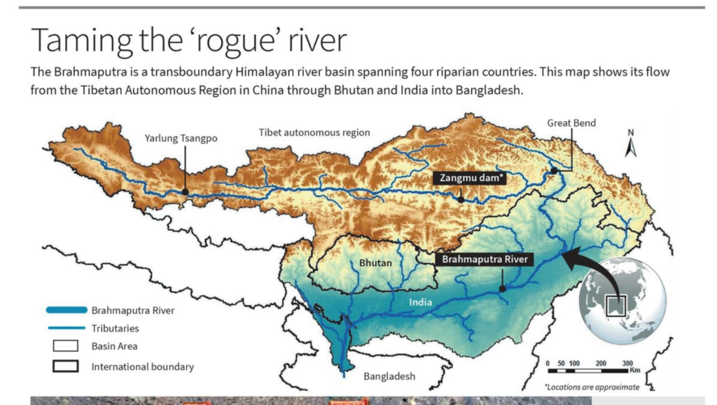
China has approved the construction of a massive 60,000 MW hydropower project—Medog Dam—at the Great Bend of the Yarlung Zangbo River (Brahmaputra), located in the Tibetan Autonomous Region (TAR). This move raises serious strategic, ecological, and geopolitical concerns for India and other lower riparian countries like Bhutan and Bangladesh.
About Medog Dam
- Location: Situated in Medog County, near the Great Bend where the Yarlung Zangbo enters Arunachal Pradesh and becomes the Brahmaputra.
- Geophysical Setting: Lies in a seismically active, high-rainfall zone in the Eastern Himalayas, close to the Indo-China border.
- Planned Capacity: 60,000 MW – expected to become the world’s largest hydroelectric project.
Strategic Significance
- Border Proximity: Located near Upper Siang, Arunachal Pradesh—a territory claimed by China as “South Tibet.”
- Military Leverage: Offers hydrological and geopolitical advantage to China over India in this sensitive region.
Geopolitical Concerns
- Riparian Power Asymmetry: Gives China complete upstream control of the Brahmaputra.
- Lack of Legal Framework: No binding water-sharing treaty among China, India, Bhutan, or Bangladesh (none are parties to the UN Watercourses Convention, 1997).
- Hydro-political Tensions: Intensifies India–China disputes, especially in Arunachal Pradesh and Ladakh.
- India’s Response: India has proposed the Upper Siang Multipurpose Project to counterbalance Chinese dominance.
Environmental and Livelihood Impacts
- Disrupted River Flow: Dam operation may alter perennial flow, affecting agriculture, fisheries, and sediment transport downstream.
- Threat to Communities: Sudden water releases could harm agro-pastoral livelihoods in Assam and Bangladesh.
- Natural Disaster Risks: The site is vulnerable to earthquakes (like the 1950 Assam–Tibet quake) and Glacial Lake Outburst Floods (GLOFs).
- Monsoon and Groundwater Effects: Upstream storage may reduce monsoon-linked recharge, affecting long-term hydrology.
- Biodiversity Loss: Threatens aquatic species, wetlands, and fish migration corridors across the Brahmaputra basin.
India’s Strategic Alternatives
- Riparian Diplomacy: Promote eco-regional water cooperation instead of escalating dam-building.
- Strengthen Expert-Level Mechanism (ELM): Enhance real-time data sharing and early warning systems with China.
- Ecological Governance: Advocate for sustainable, basin-wide river management.
- Disaster Resilience: Invest in flood-resilient infrastructure and community-based adaptation.
- Regional Coalition: Establish a Brahmaputra River Commission with Bhutan and Bangladesh for joint monitoring and planning.
Conclusion
The Medog Dam, though a technological feat, presents serious concerns for the Himalayan region’s ecological balance, water security, and regional stability. India must shift the narrative from hydro-hegemony to hydrological harmony, ensuring that the Brahmaputra remains a lifeline for millions and a model of cooperative river governance.